Cause of abnormal groundwater rise after large earthquake
How a mountain aquifer affected the local hydrological environment after a large earthquake.
Increases in groundwater levels and volumes after large earthquakes have been observed around the world, but the details of this process have remained unclear due to a lack of groundwater data directly before and after an earthquake strikes. Fortunately, researchers from Kumamoto and Kwansei Gakuin Universities (Japan) and UC Berkley (US) realized that they had a unique research opportunity to analyze groundwater level changes around Kumamoto City after large earthquakes struck the area in 2016.
Changes in the hydrological environment after an earthquake, like ponds or wells drying-up, the sudden appearance of running water, or a rise in water levels have been recorded since Roman times. Various theories have been proposed for the cause of such changes, such as fluctuations in pore water pressure (the pressure of groundwater held in the pores or gaps of rocks and soil), increased water permeability, and water movement through new cracks. To identify the actual cause, data must be collected from observation sites in wells, water sources, and rivers. However, especially in the case of inland earthquakes, it is generally rare for these sites to be spatiotemporally arranged in an area where a large earthquake has occurred. Additionally, it is even rarer to have enough data to compare before and after the disaster. These difficulties have been a roadblock to obtaining a clear picture of how hydrological environments change after earthquakes.
Kumamoto City, on the southern Japanese island of Kyushu, is famous for its water. Nearly 100% of the city’s drinking water is sourced from groundwater in the area so there are many observation wells in the area that continuously record water level and quality data. In the early morning (Japan time) of April 16, 2016, a magnitude 7.0 earthquake struck the city which resulted in a wealth of groundwater data both before and after the earthquake. Kumamoto University researchers recognized this unique opportunity to assess how earthquakes can change hydrological environments in more detail than ever before, so they established an international collaboration to study the event.
An abnormal rise in groundwater level occurred after the main shock and was particularly noticeable in the recharge area of the groundwater flow system. The water levels peaked within a year after the main shock at around 10 meters and, although it has calmed down thereafter, water levels were still high more than three years later. This was thought to be due to an inflow of water from a place not part of the pre-earthquake hydrological cycle, so researchers attempted to determine the sources by using stable isotope ratios of water.
The stable isotope ratios of water on Earth’s surface change slightly with various processes (evaporation, condensation, etc.) so they become unique marker values depending on location. These markers make it possible to determine the processes that affected a water sample as well as its source.
A comparison of the before-and-after sets of stable isotope ratios revealed that, prior to the earthquake, groundwater in the Kumamoto City area came mainly from low-elevation mountain aquifers, soil water in recharge areas, and seepage from the central Shirakawa river area. After the earthquake, the researchers believe that seismic fractures on the west side of Mt. Aso increased the permeability of the mountain aquafer which released groundwater toward the recharge area of the flow system and increased water levels. Furthermore, groundwater levels in the outflow area that had dropped immediately after the main shock were nearly restored within just one year.
"Our research is the first to capture the hydrological environment changes caused by a large earthquake in detail," said study leader Associate Professor Takahiro Hosono. "The phenomenon we discovered can occur anywhere on Earth in areas with climate and geological conditions similar to Kumamoto. We hope our research will be useful both for academics and the establishment of guidelines for regional water use in a disaster."
This research was posted online in Nature Communications on 2 June 2020.
[Source]
Hosono, T., Yamada, C., Manga, M., Wang, C.-Y., & Tanimizu, M. (2020). Stable isotopes show that earthquakes enhance permeability and release water from mountains. Nature Communications, 11(1). doi:10.1038/s41467-020-16604-y
[Publication URL]
https://www.nature.com/articles/s41467-020-16604-y
[Fund(s)]
1) JSPS Grant-in-Aid for Scientific Research B, 2) JSPS Fostering Joint International Research A, 3) SUNTORY Kumamoto Groundwater Research Project 4) JSPS Grant-in-Aid for Scientific Research C, 5) Kwansei Gakuin University Joint Research (2016), 6) Joint Research Grant for the Environmental Isotope Study of Research Institute for Humanity and Nature for Isotopic Analysis, 7) US National Science Foundation
[Numbers]
1) JP17H01861, 2) JP19KK0291, 3) NA, 4) JP17K00527, 5) NA, 6) NA, 7) 1615203
[Media 1]
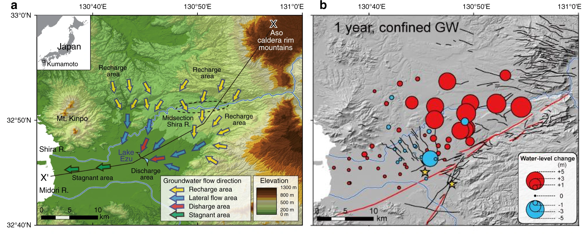
Abnormal rise in groundwater levels after the 2016 large Kumamoto earthquakes
After the Kumamoto (Japan) earthquake, an abnormal rise in groundwater level was noticeable in the recharge area of the wide-area groundwater flow system in the Kumamoto area.
a. Outline of wide area groundwater flow system in the Kumamoto area.
b. Change in groundwater level one year after the earthquake (red circle: rising, blue circle: falling).
[Images Details]
CREDIT:
Associate Professor Takahiro Hosono
USAGE RESTRICTIONS:
Adapted from Figure 1(a) and Supplementary Figure 2(h) of Hosono, T. et al., 2020
This image is made available under the terms of Creative Commons Attribution 4.0 International License. Any further distribution of this work must follow the terms of this license.
[Media 2]
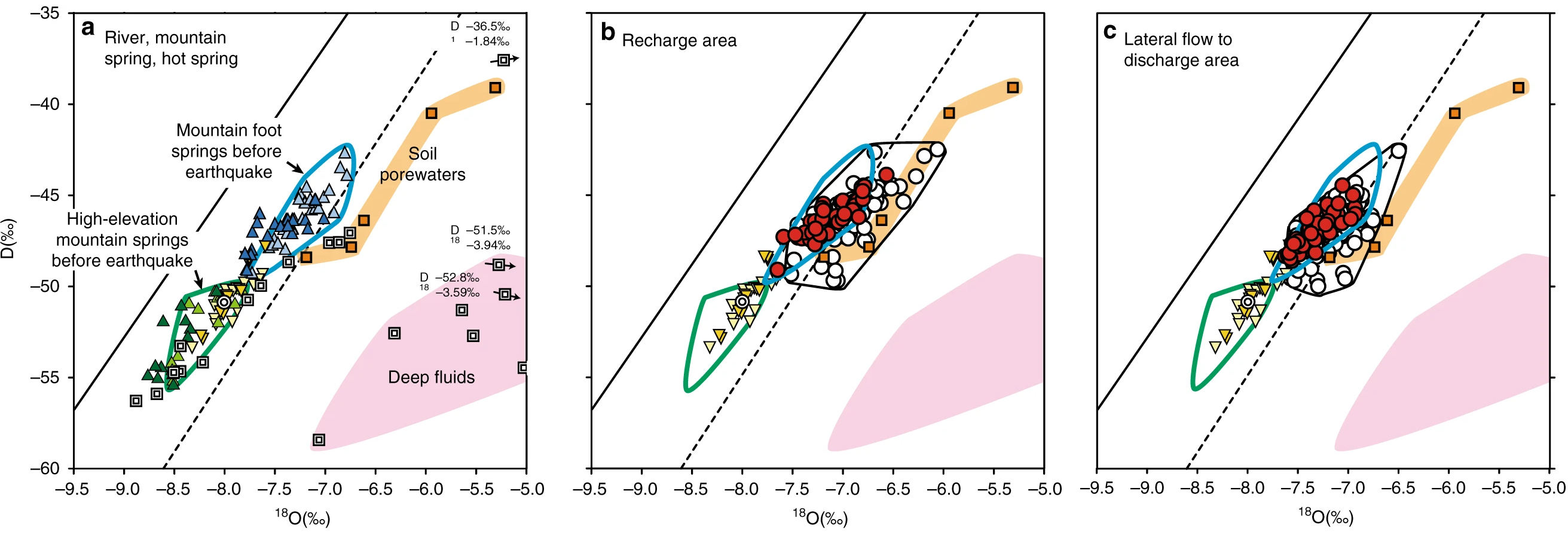
Stable isotopic compositions of various water samples
Prior to the earthquake, Kumamoto City area groundwater had broad stable isotopic compositional features that included low elevation mountain springs, recharge area soil waters, and Shirakawa river waters (black frame of b, c).
After the large 2016 earthquakes, the compositional range became more limited (blue frame of b, c), and similar to the composition of the low elevation mountain springs.
a. Comparative samples, b. Groundwater samples in recharge areas, c. Groundwater samples in flow and runoff areas
[Images Details]
CREDIT:
Associate Professor Takahiro Hosono
USAGE RESTRICTIONS:
Adapted from Figure 3(a, c, & d) of Hosono, T. et al., 2020.
This image is made available under the terms of Creative Commons Attribution 4.0 International License. Any further distribution of this work must follow the terms of this license.